Showing posts with label Walk. Show all posts

Monday, 30 August 2010

Burton Agnes, Harpham, Kilham walk. (30 August 2010)


I parked up at Burton Agnes at just gone nine o’clock for a short local, morning walk, not wanting to brave the Bank Holiday Monday traffic for too long a drive. The day was windy and overcast, but dry.

I first walked this route in August 1996. It’s got to be said that the paths are in a much better condition now than they were then, with the signage generally good and the way usually clear on the ground. I believe this is a general trend and certainly so in the East Riding.

After visiting Harpham and Lowthorpe Beck the route debunks onto the lay-by cum picnic area at Bracey Bridge. I’m told that this spot is a notorious dogging venue, but today, not a canine in sight. Seems a strange place for a terrier show… Any thoughts of a cup of tea and a bacon butty were quickly dispelled when: I’d left my cash at home.

The walk up to Kilham, following the shallow valley of Lowthorpe Beck and back over the low Wold to Burton Agnes was pleasant, if unspectacular, throughout. The long views were somewhat limited by the general gloom, although the wind farm at Lissett was a prominent and impressive feature.

Today’s walk was of about seven miles. I passed one large group of walkers near Kilham.


Burton Agnes map

Sunday, 29 August 2010

Carnaby, Boynton, High Caythorpe, Rudston 29/08/2010


Not wanting to fight the Bank Holiday traffic I settled for a return to a local circuit, a version of which was last walked two years ago, just before the C2C trip. I parked up in Carnaby village at around 09:45 hrs, just in time for the first shower. It was one of those days: bright then glowering skies, blustery then calm.

Temple Farm was as smelly and messy as ever. The nearby Temple seems to be holding up to the ravages of time: shame I can’t say the same about me…

The path down to Boynton was non-existent on the ground; the field has been recently cropped, but the direction is obvious. There is a glimpse of the front of Bessingby Hall, which seems to sit with its back to the village and its access.  

There’s a choice of three routes from Boynton to High Caythorpe. The best is probably from the Grindale road; I took the way via Low Caythorpe. This is a fine route in itself, but spoilt by a half mile walk along the B1253. The subsequent trek along the bridleway to High Caythorpe, followed by a lane and paths to Rudston is fine, with wide ranging views over the grandly named Great Wolds Valley.

After paying respects to the monolith I sat in the churchyard at Rudston to feast on apple, Mars bar and Lucozade, whilst airing my feet; a sight guaranteed to scare young children and horses. The walk up to Woldgate is along another good track giving the merest peep of Thorpe Hall: it’s surprising that such a large building is almost entirely shielded from the view of us plebs.

Woldgate, the Roman road last walked near Wetwang last week, was met. Here it’s a quiet single track lane with views to the coast and across Holderness towards the Humber. The Humber Bridge towers were clearly in sight. After a couple of hundred yards a rough track through the newly harvested fields heads back to Carnaby and the car.

Today’s walk was of about eleven miles. There was little evidence of the paths and tracks being used much. No other walkers and only a couple of mountain bikers were met. Despite this the walk is of high quality (the B1253 excepted) throughout.

My foot problems seem to now be firmly in the past and my stamina is improving.   


2010-08-29

Sunday, 22 August 2010

Wetwang Circular 22 August 2010


It was a fine warm day today. I was buying cold Lucozade at the Wetwang stores by 09:45 and off across the fields by ten. I was following a route suggested on the East Riding of Yorkshire Council’s walks website. For the first half mile it coincided with the Chalkland Way, a route I followed about five years ago, before leaving it to join a fine green lane heading east.

The green lane forms part of the Woldgate Roman road between Bridlington and York. It was probably old before the arrival of the legions and looks like it last saw heavy use as a drove road before the arrival of the railways. It makes for pleasant walking with wide ranging views across the Wolds and Holderness.

Sledmere Monument is a prominent feature of the view ahead. I left the lane a half mile before reaching it, however, to head south. The track of the long abandoned Driffield to Malton railway was the next feature of interest, followed by a view into the quarry at Garton Slack, the site of Iron Age chariot burials.

I’ve frequently driven along the A166 road. Always the road appears scenic, rural and pleasant. To approach and cross it from the fields, it was noisy, smelly and intrusive. Funny how walking in familiar areas gives things a new perspective…

The route met a surfaced lane to head east for a short distance, before joining another green lane. The walk here was through well wooded, shaded, field boundaries. The way was then left to head north, through Thorn Dale, back to Wetwang.

The route was about nine miles in length and in very pleasant, if unspectacular country, throughout. I passed half a dozen other walkers, mainly accompanied by dogs, and a couple of mountain bikers on one of the green lanes. My feet survived unscathed.        

Sunday, 8 August 2010

N Frodingham, Foston, Brigham, Hempholme Walk


It’s a couple of weeks since my Warter outing: the blisters have just healed. Must remember to carry plasters and dressings next time I experiment with boot inserts… We live an learn.

I didn’t want to tempt fate and try anything too energetic today. A walk in the flatlands of Holderness was the order of the day. Although I’ve lived in the area for many years and, where I hit tarmac I knew the roads well, I’ve never actually walked any of today’s paths. Today was an odd mix of the new and the familiar.

I parked up in North Frodingham and walked north along a green lane towards Foston on the Wolds. I would guess the lane would be muddy after rain; it got progressively rougher before petering to a narrow footpath and crossing a couple of water courses into the southern tip of the village near an attractive old mill.

A hare practically ran into me on the otherwise quiet lane to Brigham, near a recently squashed grass snake: when did I last see a live one?

A family of swans graced the canal at Brigham, at the start of a three mile walk down the navigation. The canal merges with Frodingham Beck, a branch of the canal, and, a short distance further, with the River Hull at West Beck. The water and drainage channels are somewhat complicated in these parts, the area hovers around sea level and the map is littered with Ings and Carrs: it must have had a very soggy history.  

Bethell’s Bridge sports lots of boats in varying degrees of upkeep. I doubt some have moved in years. Instead, the moorings are decorated with sheds and small gardens. More caravaners than corsairs…

Just south of the bridge, whilst passing the large wooded area at Struncheon Hill Farm, I almost stood on a vole.

The river was crossed at the lock north of Top Hill Low and left for a footpath to the hamlet of Hempholme. There the route followed a line of old gravel workings; long abandoned and now a series of bonny, well wooded ponds and small lakes; much of the way back to North Frodingham

Today’s walk was eight miles in hot and humid weather. The route was much more rewarding than I’d anticipated and the paths, although largely unfrequented, were clear and well marked throughout. Birds and water fowl were plentiful and the water was everywhere teeming with fish. Did I mention the hare and vole? 


Monday, 8 June 2009

Wharrem Percy, Thixendale Circular (Monday 8 June 2009)

Near Thixendale
Towards the dale of Thixen Dale
Descent to Thixendale
Honey Dale

Medieval gravestone set into Wharrem Percy church wall

Fish pond, Wharrem Percy
St Martin's Church Wharrem Percy

I’d bought boots over the weekend, a pair of Brasher Lithium XCRs. Today was a leave day, bright, but not too warm; time to test-drive the new footwear.

In view of the sensitive nature of my feet I decided against anything too challenging and opted for a revisit to the Wolds for a favourite walk last done in July. So, off to Wharrem Percy it was for an eleven o’clock start from the medieval village visitor car park.

The walk is a popular outing and uses a figure of eight route alternating between parts of the Yorkshire Wolds Way and Centenary Way. I varied the walk over past visits by visiting Vessey Pasture Dale on the outward leg and entering Thixendale from the west. This, incidentally, seems the slightly easier option, using the steep Wolds Way path at Thixendale in descent.

The boots seemed comfortable at first, light, with plenty of support. As the day progressed, however, I developed hot spots on the soles of both feet which, by the end of the walk, had developed into full blown and rather painful blisters. I don’t think this is a fault of the boot; it’s just the usual war of attrition I always have to endure before my feet accept new footwear.

It was pretty quiet on the route: I passed just one other set of four walkers and a morose youth sat in a farm vehicle using all of his limited ingenuity to ignore my presence. There was plenty of bird and insect life on display, including lots of tortoiseshell butterflies, but no larger animals.

The pub at Thixendale was closed but I found a reasonably restful perch at the village cricket pavilion to chew my banana and apple and air my toes. It got pleasantly warm during the middle of the day with surprisingly strong sunlight: enough to lightly toast exposed skin.

The highlight of the return leg is the descent into Deepdale and Wharrem Percy. Wharrem Percy has a very agreeable setting which always attracts a smattering of visitors. In truth there’s not a lot of the medieval village to see, just humps and bumps on the ground, a pond and a ruined church. There are plenty of interpretation boards, however, and even the least imaginative can get some appreciation of the site’s past.

I finished the ten mile walk blistered, sweaty and sunburnt: I must get back into a regular weekly walk routine to regain some of the fitness I had at the end of last year’s Coast to Coast walk.

Saturday, 23 May 2009

Reeth to Carperby

Wednesday 28 April 2009

(Walking Distance: 11 miles)

Greets Hill

Bolton Castle

Breakfast was interesting. All the other guests were members of the vocal ladies walking group last met in the Kings Arms. They were, like me, heading home today. Coincidentally the walk leader came from Swainby, near Northallerton, my lift, John’s, birthplace. She knew his brother.

It was a dry, pleasant, if hazy, morning. I left for what I’d anticipated to be an easy ten mile walk to Aysgarth, where I’d arranged to meet John. The route headed south over moorland back into Wensleydale, crossing Apedale, an intervening valley, before descending to the River Ure.

Except in complicated surroundings I try to avoid walking with my nose in the map, preferring to study the route beforehand and navigating from memory, with only occasional reference to the Ordinance Survey or guidebook. This approach usually works well leaving the mind free to absorb and admire the surroundings. It does, however, have some drawbacks

I walked up the lane, passing a minor junction and the youth hostel, before hauling myself up onto the open moor. I was looking for a track off to the right: I found one but it didn’t quite match the description I’d read earlier. I belatedly consulted the map and realised I’d missed the lane to Redmire and continued along the road to Leyburn.

The good news was that I heard the first cuckoo of the season on the way up. The bad news was the two and a half miles extra distance and three hundred foot of wasted ascent.

Eventually I got back on route and found the track across the moor to the day’s highpoint, Greets Hill. The weather didn’t deliver the promised vista, however. Whilst the mist wasn’t bad enough to hinder navigation it limited the view to just a mile or two.

Apedale was suitably bleak, Black Hill was almost easy: might be getting fitter? I stopped for a break above Bolton Castle when the sun finally appeared.

It was getting near the three o’clock appointment with my lift. In the pastures after Bolton Castle my phone sprang to life, the first signal of the trip. It was John. Another half mile and I was done.

Askrigg to Reeth

Tuesday 28 April 2009
(Walking Distance: 12 miles)

Rain over Wensleydale

Another dire day forecast. At least it was dry for breakfast, and a very good one it was too. I’d like to have a weekend with Rita at the Manor House in the not too distant future. I’m told there’s a four post bed; I just hope the sciatica doesn’t return.

By the time I was packed up, got the shopping done and unfurled the Pacerpoles it was 9:45. The route over to Swaledale was via a minor road over Askrigg Common, then by a not-quite green lane (one with metalled, parallel tracks) above Oxnop Gill, down to Ivelet Bridge.

I struggled to the cattle grid on the open moor, only to look back into Wensleydale to see a lady jogger making short work of the climb. We chatted for a minute whilst I was donning waterproofs. The rain swept along the valley and hit us with a vengeance. It stayed with me for the rest of the day.

Although the first few miles were on roads, they were very quiet ones: only a couple of cars passed by on the Muker road and none at all on the lane to Satron.

When the mists swirled and cleared the surroundings were magnificent, often it was face down and head into the wind. Swaledale’s grand when you can see it. The rain didn’t ease when the moor was forsaken for the valley.

The Inn Way route headed high up along the valley side after the waterfall on Haverdale Beck, near Crackpot; I opted for a lower route shadowing the Swale. And so I plodded along not seeing another walker all day. After a couple of years of abstinence from red meat, give or take the occasional chop, I found myself fantasising over a plate of bangers and mash as I trudged along.
I was in Reeth by about three-thirty. I checked in at Hackney House at four.

The weather had tested my kit which, by and large, had stood the test. Underneath the waterproofs I was dry. My £120.00 Meindl boots faired less well: they leaked. On closer examination the right heel was parting company with the rest of the boot. The heel and stitching had failed last year on the Coast to Coast walk; this was their first outing since a factory repair. Brasher can anticipate a sale soon, Meindl never again.

Hackney House was grand with a large, comfortable, maybe slightly faded room.

Other than a vocal ladies walking group in the King’s Arms, Reeth was quiet. The pub fulfilled my fantasy by providing a posh but tasty version of bangers and mash.

Accommodation:

Hackney House
Bridge Terrace
Reeth
North Yorkshire
DL11 6TW
Telephone: 01748 884302

Buckden to Askrigg

Monday 27 April 2009
(Walking Distance: 12 miles)

Cragdale
Ruined Chapel, Stalling Busk
Semerwater
Track around Semerwater
Semerwater
Locals
Valley of the River Bain
Bainbridge
The day dawned wet with a dismal forecast for the rest of the day. The hotspot on my toe had developed into a fully fledged, but not too painful, blister. Waterproofs and Compeed are the order of the day. On the bright side my back was pain free.

Breakfast was a tasty, leisurely affair with no one in a hurry to begin the fight with the elements. A couple from Harrogate and a solo walker had shared the accommodation, both parties walking the Dales Way. The solo walker, a chap in his early twenties, was heading for Ribblehead, whilst the couple had a 20 mile hike ahead all the way to Dent.

I was gathered up and away shortly after nine.

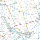
Whilst I was familiar with the general area, today’s route was entirely along new ground. And very special ground, despite the weather, it proved to be. The route raises to the top of the Kidstones Pass, crosses Stake Moss to Cragdale, Raydale and Semerwater, before entering Wensleydale by way of the River Bain.

Despite the driving rain I made good progress along the Rake, the long pull up to the summit of Stake Moss and the magnificent high level yomp, along mainly green tracks and paths, to Stalling Busk. The big tops remained in cloud throughout.

At over a thousand foot elevation Stalling Busk’s daffodils were hardly out of bud. Its ruined abandoned chapel, a way out of the hamlet, provided a tranquil and comfortable lunch stop: the rain eased, then stopped; a new bench gave succour to aching limbs. It’s a very attractive spot to while away half an hour, munch apples and swig coffee: not good for people watching though.

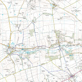
The walk around the Semerwater was a little reminiscent of the Lakes, although Alfred Wainwright had apparently once described the tarn as a "muddy puddle". Bird life was prolific.

There were no walkers out today until a long crocodile was met wandering in expensive gear and noticeably mud free boots down the lane from Countersett to the shores of Semerwater.

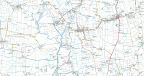
In increasingly verdant surroundings I walked to Bainbridge, then along the top of Brough Scar, where another break was had, to Worton and Askrigg.

The Mark Reid book suggested a route passing Nappa Hall, but the gathering clouds dictated a more direct route across the fields to the village. I didn’t quite beat the rain, getting another soaking during the last quarter mile of the day.

The Manor House is a very comfortable and impressive Georgian town house in the centre of the village. The reception was welcoming, although I was conscious of dragging my muddied self into the otherwise pristine pile. I was the only guest.

There was little activity in any of Askrigg’s three pubs, but a reasonable meal was had before an early night.

Accommodation:

Manor House
Main Street
Askrigg
North Yorkshire
DL8 3HQ
Telephone: 01969 650986
£40.00

Thursday, 21 May 2009

Arncliffe to Buckden

Sunday 26 April 2009

(Walking Distance: 7 miles)

Arncliffe
Littondale
Towards Pen-y-ghent
Buckden

The decision was made: Wharfedale after an early breakfast via a lift with number one son to begin a four day trip following a route inspired by Mark Reid's guide, “The Inn Way…to the Yorkshire Dales”.

So, here we are: midday, a full pack, sunny weather and a bed booked in Buckden, seven short, but rather steep, miles away. It’s my first day out since the Coast to Coast Walk back in September and my first with a full pack since my September 2007 walk along the Cumbria Way (the Packhorse having given sterling service shifting my bag along the C2C).

And thereby hung some concern... After the Cumbria Way I suffered a two month bout of sciatica, perhaps triggered by lugging a rucksack up and down some modest Lakeland Fells. Today, and for the past few days, I’d had niggling back pain. Would the walk lay me low for the next few weeks?

Littondale was lovely. The first swallows (or were they swifts?) of the season greeted me in Arncliffe. I bade farewell to my lift and gingerly lifted my not-too-heavy pack onto my all-too-tender shoulders.

After a couple of easy and pleasant miles to Litton, and a glass of pretend (alcohol free) lager the reality of the enterprise hit home. Birks Fell qualifies as a mountain by a smidgen: according to the book just topping 2000 foot by a few inches. It’s also very steep. It was, in truth, a bit of a sweaty struggle to get to the top. A winter of indolence exerted its painful toll. The Dutch couple who breezed effortlessly past me on the ascent had no such problems; they lacked the decency even to perspire.

The reward on a bright, clear spring afternoon amply repaid the pain. Grandly displayed was distant Pendle, nearer, Pen-y-ghent. The verdant trench of Wharfedale was flanked by the shapely heights of Simon’s Seat, Great Whernside and Little Whernside. Viewed from the ridge, however, Buckden Pike dominates.

It was good to be out. Time was plentiful. The curlews and lapwings were in song. The enjoyable amble off the hill down to Buckden was broken with a chat to a chap from Birmingham collecting Nuttalls: hills in England and Wales over 2,000 feet (610 m) with a relative height of at least 15 metres (49 ft).

I should have started the day nearer to Grassington. Despite my slow going I was in Buckden by 15:30hrs. I passed half an hour watching the world go by from a bench on the green before booking in at the fairly basic, but very comfortable and good value, B & B. The rooms are above a tearoom and, for good measure, a cuppa and bun are thrown in on arrival.

Buckden has a singular cafĂ© offering good food in agreeable, unpretentious surroundings, with mildly eccentric and entertaining service. It’s infinitely preferable to the now sadly faded pub.

I’d had a good day. Other than a hotspot on my big toe no damage had been done. In fact for the first time in days the niggling backache had disappeared.

Accommodation:

West Winds Yorkshire Tearooms

Buckden

Skipton

BD23 5JA

Telephone: 01756 760883

£30.00