I had an earlyish start today; I was walking along the Roman Road out of Warter by ten o’clock, after a twenty-odd drive from home. The route started with a steady near four hundred foot climb up to the wold top in hot and humid conditions.
The Wolds aren't high, but they stand proud from the surrounding plains giving extensive views: Holderness, the Vale of York, Hull and, over the Humber, Lincolnshire. The wind farm at Lissett is a new feature of views from the Wold tops, giving a good indication of the coast south of Bridlington.
The lanes hereabouts are quiet and not at all unpleasant to walk along. Indeed, on this Sunday morning, the four or five passing bicycles easily outnumbered cars. The tarmac was left at Cobdale Cottage to join a terrific green lane, the Hawold Bridle Road, for the next three miles.
I’d last been this way about five years ago when walking the Minster Way, a route between Beverley and York. Since then Well Dale, running south from the track, has become open access land. My impression is that the landowners aren't over enamoured with the new arrangements: the information board has been vandalised with a nail, the access gate is festooned with a home made notice, “Warning Gas Guns in Operation!” and a new fence has been imposed on the landscape. Despite these minor annoyances, and despairing of the selfish attitude of the few, the walking was grand.
The track passed a large area of polytunnels filled with strawberries, enough to accompany a tanker full of cream. The aroma was magnificent. Scorning temptation I passed without sin.
I left the Minster Way at Blanch Farm.
Lavender Dale is now Open Access land allowing an easy walk along the dale bottom instead of clinging to its top edge. After a steep pull out of the dale there were more fine tracks before joining the lane just outside Warter.
I’m afraid my not-so-new boots continue to wreck my feet. I’d bought new insoles thinking they might help: a pair of Sorbothane type ones and a pair of light Odour Eater type. I started well with the heavy duty insoles until my heels became sore. I swapped to the lightweight ones which promptly rucked up inside my boot before being discarded. The net result of my experiment was painful, skinless heels. Back to the drawing board.
Feet apart, I was fine...
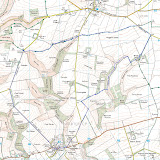
The day’s walk was a shade under ten miles. The route was courtesy of East Riding of Yorkshire walking website.
The Wolds aren't high, but they stand proud from the surrounding plains giving extensive views: Holderness, the Vale of York, Hull and, over the Humber, Lincolnshire. The wind farm at Lissett is a new feature of views from the Wold tops, giving a good indication of the coast south of Bridlington.
The lanes hereabouts are quiet and not at all unpleasant to walk along. Indeed, on this Sunday morning, the four or five passing bicycles easily outnumbered cars. The tarmac was left at Cobdale Cottage to join a terrific green lane, the Hawold Bridle Road, for the next three miles.
I’d last been this way about five years ago when walking the Minster Way, a route between Beverley and York. Since then Well Dale, running south from the track, has become open access land. My impression is that the landowners aren't over enamoured with the new arrangements: the information board has been vandalised with a nail, the access gate is festooned with a home made notice, “Warning Gas Guns in Operation!” and a new fence has been imposed on the landscape. Despite these minor annoyances, and despairing of the selfish attitude of the few, the walking was grand.
The track passed a large area of polytunnels filled with strawberries, enough to accompany a tanker full of cream. The aroma was magnificent. Scorning temptation I passed without sin.
I left the Minster Way at Blanch Farm.
Lavender Dale is now Open Access land allowing an easy walk along the dale bottom instead of clinging to its top edge. After a steep pull out of the dale there were more fine tracks before joining the lane just outside Warter.
I’m afraid my not-so-new boots continue to wreck my feet. I’d bought new insoles thinking they might help: a pair of Sorbothane type ones and a pair of light Odour Eater type. I started well with the heavy duty insoles until my heels became sore. I swapped to the lightweight ones which promptly rucked up inside my boot before being discarded. The net result of my experiment was painful, skinless heels. Back to the drawing board.
Feet apart, I was fine...
The day’s walk was a shade under ten miles. The route was courtesy of East Riding of Yorkshire walking website.