Monday 30 August 2010

Burton Agnes, Harpham, Kilham walk. (30 August 2010)


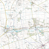
I parked up at Burton Agnes at just gone nine o’clock for a short local, morning walk, not wanting to brave the Bank Holiday Monday traffic for too long a drive. The day was windy and overcast, but dry.

I first walked this route in August 1996. It’s got to be said that the paths are in a much better condition now than they were then, with the signage generally good and the way usually clear on the ground. I believe this is a general trend and certainly so in the East Riding.

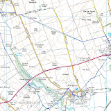
After visiting Harpham and Lowthorpe Beck the route debunks onto the lay-by cum picnic area at Bracey Bridge. I’m told that this spot is a notorious dogging venue, but today, not a canine in sight. Seems a strange place for a terrier show… Any thoughts of a cup of tea and a bacon butty were quickly dispelled when: I’d left my cash at home.

The walk up to Kilham, following the shallow valley of Lowthorpe Beck and back over the low Wold to Burton Agnes was pleasant, if unspectacular, throughout. The long views were somewhat limited by the general gloom, although the wind farm at Lissett was a prominent and impressive feature.

Today’s walk was of about seven miles. I passed one large group of walkers near Kilham.


Burton Agnes map

Sunday 29 August 2010

Carnaby, Boynton, High Caythorpe, Rudston 29/08/2010


Not wanting to fight the Bank Holiday traffic I settled for a return to a local circuit, a version of which was last walked two years ago, just before the C2C trip. I parked up in Carnaby village at around 09:45 hrs, just in time for the first shower. It was one of those days: bright then glowering skies, blustery then calm.

Temple Farm was as smelly and messy as ever. The nearby Temple seems to be holding up to the ravages of time: shame I can’t say the same about me…

The path down to Boynton was non-existent on the ground; the field has been recently cropped, but the direction is obvious. There is a glimpse of the front of Bessingby Hall, which seems to sit with its back to the village and its access.  

There’s a choice of three routes from Boynton to High Caythorpe. The best is probably from the Grindale road; I took the way via Low Caythorpe. This is a fine route in itself, but spoilt by a half mile walk along the B1253. The subsequent trek along the bridleway to High Caythorpe, followed by a lane and paths to Rudston is fine, with wide ranging views over the grandly named Great Wolds Valley.

After paying respects to the monolith I sat in the churchyard at Rudston to feast on apple, Mars bar and Lucozade, whilst airing my feet; a sight guaranteed to scare young children and horses. The walk up to Woldgate is along another good track giving the merest peep of Thorpe Hall: it’s surprising that such a large building is almost entirely shielded from the view of us plebs.

Woldgate, the Roman road last walked near Wetwang last week, was met. Here it’s a quiet single track lane with views to the coast and across Holderness towards the Humber. The Humber Bridge towers were clearly in sight. After a couple of hundred yards a rough track through the newly harvested fields heads back to Carnaby and the car.

Today’s walk was of about eleven miles. There was little evidence of the paths and tracks being used much. No other walkers and only a couple of mountain bikers were met. Despite this the walk is of high quality (the B1253 excepted) throughout.

My foot problems seem to now be firmly in the past and my stamina is improving.   


2010-08-29

Sunday 22 August 2010

Wetwang Circular 22 August 2010


It was a fine warm day today. I was buying cold Lucozade at the Wetwang stores by 09:45 and off across the fields by ten. I was following a route suggested on the East Riding of Yorkshire Council’s walks website. For the first half mile it coincided with the Chalkland Way, a route I followed about five years ago, before leaving it to join a fine green lane heading east.

The green lane forms part of the Woldgate Roman road between Bridlington and York. It was probably old before the arrival of the legions and looks like it last saw heavy use as a drove road before the arrival of the railways. It makes for pleasant walking with wide ranging views across the Wolds and Holderness.

Sledmere Monument is a prominent feature of the view ahead. I left the lane a half mile before reaching it, however, to head south. The track of the long abandoned Driffield to Malton railway was the next feature of interest, followed by a view into the quarry at Garton Slack, the site of Iron Age chariot burials.

I’ve frequently driven along the A166 road. Always the road appears scenic, rural and pleasant. To approach and cross it from the fields, it was noisy, smelly and intrusive. Funny how walking in familiar areas gives things a new perspective…

The route met a surfaced lane to head east for a short distance, before joining another green lane. The walk here was through well wooded, shaded, field boundaries. The way was then left to head north, through Thorn Dale, back to Wetwang.

The route was about nine miles in length and in very pleasant, if unspectacular country, throughout. I passed half a dozen other walkers, mainly accompanied by dogs, and a couple of mountain bikers on one of the green lanes. My feet survived unscathed.        

Sunday 15 August 2010

Reighton to Flamborough


It was another shortish walk again today. At the risk of sounding like a medical blog, I’ve not had a good week: head cold, sore throat and half deaf from an ear infection. Perhaps a walk would help to sweat the infection out of my system (kill or cure is the theory).

I parked up at Flamborough where I met William and Jocelyn, my son and daughter-in-law, for a lift over to Reighton and a walk back along the cliffs to the car.  There are good field paths to Speeton, including a short section of trail which is apparent on the ground but missing from the OS map.

On the way to the cliff top the path passes St Leonard’s Chuch, an ancient structure and one of the smallest parish churches in England. I’ve never noticed before but there are no windows along the eastern, seaward, wall: that’s Norman draught proofing for you!  

After initially dropping towards the shore the path rises to the top of the high cliffs. Unfortunately, Filey Bay and the cliff tops were engulfed in a sea-roak. During the climb the path teeters on the edge of the drop. Any illusion of protection is quickly shattered by the decrepit condition of the broken down post and wire fence. The track is safe enough in dry conditions but I wouldn’t tackle it in snow.  

The excitement ends on gaining the cliff top. The remainder of the walk is a glorious airy parade high above the North Sea. The high point of the ramble is at the triangulation pillar sat on Speeton Cliffs 344 feet above the rocky beach. In less misty conditions the coast can be traced as far north as Ravenscar (I think), whilst the view south takes in Holderness, the Humber Bridge and over the river to the Lincolnshire Wolds. Today I couldn’t see the field boundary.  

I saw the first few gannets shortly afterwards as the mist began to lift and got a whiff of the colony soon after. It got quite busy with people too through the RSPB reserve at Bempton Cliffs. The puffins have left, but gannets, fulmars and kittiwakes remain.

Danes Dyke reaches its northern terminus at the cliff. It is said to have Bronze Age origins but remains a massive structure, resembling a railway embankment. The dyke dissects Flamborough Head and cries out for access along its length.

I arrived in Flamborough in good time and in fair condition. Recent foot problems seem to be resolved. The walk was of about 8 miles.      

From Recently Updated

Sunday 8 August 2010

N Frodingham, Foston, Brigham, Hempholme Walk


It’s a couple of weeks since my Warter outing: the blisters have just healed. Must remember to carry plasters and dressings next time I experiment with boot inserts… We live an learn.

I didn’t want to tempt fate and try anything too energetic today. A walk in the flatlands of Holderness was the order of the day. Although I’ve lived in the area for many years and, where I hit tarmac I knew the roads well, I’ve never actually walked any of today’s paths. Today was an odd mix of the new and the familiar.

I parked up in North Frodingham and walked north along a green lane towards Foston on the Wolds. I would guess the lane would be muddy after rain; it got progressively rougher before petering to a narrow footpath and crossing a couple of water courses into the southern tip of the village near an attractive old mill.

A hare practically ran into me on the otherwise quiet lane to Brigham, near a recently squashed grass snake: when did I last see a live one?

A family of swans graced the canal at Brigham, at the start of a three mile walk down the navigation. The canal merges with Frodingham Beck, a branch of the canal, and, a short distance further, with the River Hull at West Beck. The water and drainage channels are somewhat complicated in these parts, the area hovers around sea level and the map is littered with Ings and Carrs: it must have had a very soggy history.  

Bethell’s Bridge sports lots of boats in varying degrees of upkeep. I doubt some have moved in years. Instead, the moorings are decorated with sheds and small gardens. More caravaners than corsairs…

Just south of the bridge, whilst passing the large wooded area at Struncheon Hill Farm, I almost stood on a vole.

The river was crossed at the lock north of Top Hill Low and left for a footpath to the hamlet of Hempholme. There the route followed a line of old gravel workings; long abandoned and now a series of bonny, well wooded ponds and small lakes; much of the way back to North Frodingham

Today’s walk was eight miles in hot and humid weather. The route was much more rewarding than I’d anticipated and the paths, although largely unfrequented, were clear and well marked throughout. Birds and water fowl were plentiful and the water was everywhere teeming with fish. Did I mention the hare and vole? 


Sunday 25 July 2010

Warter Circular Walk 25 July 2010


I had an earlyish start today; I was walking along the Roman Road out of Warter by ten o’clock, after a twenty-odd drive from home. The route started with a steady near four hundred foot climb up to the wold top in hot and humid conditions.

The Wolds aren't high, but they stand proud from the surrounding plains giving extensive views: Holderness, the Vale of York, Hull and, over the Humber, Lincolnshire. The wind farm at Lissett is a new feature of views from the Wold tops, giving a good indication of the coast south of Bridlington.

The lanes hereabouts are quiet and not at all unpleasant to walk along. Indeed, on this Sunday morning, the four or five  passing bicycles easily outnumbered cars. The tarmac was left at Cobdale Cottage to join a terrific green lane, the Hawold Bridle Road, for the next three miles.

I’d last been this way about five years ago when walking the Minster Way, a route between Beverley and York. Since then Well Dale, running south from the track, has become open access land. My impression is that the landowners aren't over enamoured with the new arrangements: the information board has been vandalised with a nail, the access gate is festooned with a home made notice, “Warning Gas Guns in Operation!” and a new fence has been imposed on the landscape. Despite these minor annoyances, and despairing of the selfish attitude of the few, the walking was grand.

The track passed a large area of polytunnels filled with strawberries, enough to accompany a tanker full of cream. The aroma was magnificent. Scorning temptation I passed without sin.

I left the Minster Way at Blanch Farm.

Lavender Dale is now Open Access land allowing an easy walk along the dale bottom instead of clinging to its top edge. After a steep pull out of the dale there were more fine tracks before joining the lane just outside Warter.

I’m afraid my not-so-new boots continue to wreck my feet. I’d bought new insoles thinking they might help: a pair of Sorbothane type ones and a pair of light Odour Eater type. I started well with the heavy duty insoles until my heels became sore. I swapped to the lightweight ones which promptly rucked up inside my boot before being discarded. The net result of my experiment was painful, skinless heels. Back to the drawing board.

Feet apart, I was fine...     

The day’s walk was a shade under ten miles. The route was courtesy of East Riding of Yorkshire walking website.


Sunday 18 July 2010

Fordon Circular 18 July 2010


I had a short, but sweaty, five mile, local walk today, from the hamlet of Fordon. It’s a walk I’ve done quiet a few times over the years, with variants and as part of longer outings; the last time being in August 2008, just before my Coast to Coast walk.

The route explores dry Wolds valleys and touches briefly on the Yorkshire Wolds Way.

The way has improved since my last visit; the addition of a new style into the eastern extremity of access land at Fordon Banks saves a good half mile of road walking and substitutes flower, bird and insect rich, unimproved, chalk grassland, for tarmac (the half dozen hares and a Sparrow Hawk, disturbed on my traverse, seemed to enjoy it too).

The walk uses an green lane from East Dale onto the Wold top at Danebury Manor. The old farm house was in a sorry semi-ruinous state in 2008, but has now been resurrected and is in the final stages of a complete renovation (it could be now two, if not three, new dwellings).

As usual the Wolds Way showed no sign of walkers, nor did Lang Dale or North Dale on the pleasant walk back to Fordon. The big black bull in a field near the hamlet, fortunately, was more interested in his harem than my presence.